

The City Council of Chelva, in its session held on June 8, unanimously agreed to request the final approval of the Structural General Plan from the Valencia Territorial Planning Commission, thus taking a giant step towards completing the plan’s processing. The final proposal for this plan, drafted by AUG-ARQUITECTOS, SLP, incorporates the corrections requested by the environmental body in the Strategic Environmental and Territorial Declaration and, once approved, will represent a significant improvement in the planning of this interesting inland town in the province of Valencia.
The Chelva Town Council has been working since the first decade of this century to promote a complete revision of its planning framework, which consists of Subsidiary Regulations approved in 1989 and other planning instruments. After a complex process involving other drafting teams, in 2018 the Chelva Town Council requested a grant and technical assistance from the Valencia Provincial Council for the development of the General Structural Plan (already underway) and the Detailed Planning Plan. The winning bid was submitted by AUG-ARQUITECTOS SLP, and under the direction of urban planner and architect Víctor García Gil, they became the new drafting team.
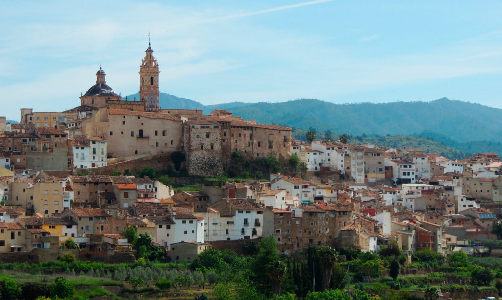
Planning a municipality like Chelva is complex because it is very large, with several inhabited areas and a rich heritage, primarily embodied in the Historic-Artistic Site of Chelva and its surrounding orchards, although there are also elements of great interest throughout the rest of the municipality.
Regarding the main objectives of the new plan, we must emphasize what should guide any decision made concerning the future of the town, whether it comes from the local administration or any other body. We are referring to the need to develop measures and models (in this case, urban planning) to combat depopulation. If the European Parliament considers that they present an extreme risk of depopulation, areas with a density below 8 inhabitants per square kilometer, in Chelva, with a density of 8.80 inhabitants/km², compared to the provincial average of 235.12 (ARGOS 2017) and a gradual process of population loss, all alarm bells should be ringing.
Therefore, for the purposes of interpreting the regulatory section of the General State Budget (PGE), it is emphasized that, in case of contradiction or doubt regarding the content of NNUU regulations or plans with regulatory force, the decision that facilitates the retention of the population and allows for combating rural exodus should prevail. This interpretation is explained by the fact that, despite a very worrying demographic outlook, Chelva has sufficient resources to guarantee its sustainability, an agricultural sector that must be preserved, and—above all—a landscape and heritage of great interest. It is precisely in the balance between heritage conservation and economic growth that the key to a prosperous and sustainable future may lie.
Curiously, despite Chelva being a regional and provincial landmark for its heritage and boasting (its main town center) good road connections to Valencia, the town has not established itself as an attractive destination for cultural tourism, which typically seeks heritage, quality restaurants, and hospitality as the ideal location for a short or medium-term stay. Unfortunately, most visitors to Chelva only stay for a few hours and leave little to no economic benefit for the town, as many do not even purchase local products or services. Consequently, the restaurant and hospitality offerings are limited and of low quality, due to the perceived low profitability of these types of businesses in the current economic climate. Reversing this situation, by opting for a controlled development plan, creating economic opportunities, facilitating not only vehicular access but also parking for visitors and those who own property or wish to stay overnight in the old town, implementing inclusive urban planning, and improving public facilities, are some of the tools that the Structural General Plan (PGE) and the Detailed Ordination (POP) of Chelva propose to promote in order to strengthen economic recovery.
The planning measures must also contribute to encouraging a change in mindset that we consider essential if we want to commit to a sustainable future in these types of towns. We are referring to the need to invest in high-quality projects that help overcome the current low profile, given the progressive environmental degradation that a significant part of the urban fabric has experienced in recent decades. The same requirements for compliance with minimum standards of quality and architectural correctness that have been demanded and achieved in the area included within the Historic-Artistic Site must be applied to the rest of the urban land, through the application of the corresponding ordinances. Much of Spain, and especially neighboring countries (Italy, France, the United Kingdom, etc.), offer paradigmatic examples of towns similar to Chelva that have entrusted their future to the conservation of their heritage and the implementation of quality initiatives, successfully attracting tourists with a certain level of purchasing power, which has decisively contributed to the economic well-being of the local population. The development model that Chelva can adopt is comprehensive and is based on incentivizing synergies through the strengthening of a high-quality service sector. The workforce and the returns generated by this sector stimulate other areas, such as industry, construction, and so on. But what is clear is that the mere construction of ugly, impersonal, and misplaced buildings, as has been done across much of Chelva’s land in recent decades, only contributes to the vulgarization of the urban landscape and serves the immediate needs of those involved in these developments or construction projects, while discouraging a sustainable economy with the capacity to drive recovery.
The plan must help to definitively overcome an individualistic view of actions related to building, infrastructure, landscape, the environment, etc. In other words, it must engage everyone (including the government) in exemplary actions and must also help dismantle the argument that prioritizing quality at all levels is more expensive and therefore impractical in a subsistence economy, as is the case in many parts of Chelva. Many towns that have managed to attract quality initiatives suffer or have suffered even worse economic situations than those that may exist in Chelva and had fewer human and material resources. Ultimately, it is a matter of attitude, a strategic decision that, in a general plan, can be translated into a series of objectives and measures to achieve them.
The objectives that the new plan aims to achieve, with regard to structural planning and the development of the determinations and observations outlined in the Scope Document and the Strategic Environmental and Territorial Declaration, are as follows:
- From an environmental and landscape perspective, the attribution to a large portion of rural land of the appropriate and necessary level of protection to safeguard its values, consistent with the various protection categories that determine land classification and zoning.
- With regard to protected non-urbanizable land, which comprises 94.27% of the municipality, the establishment of regulations that, to ensure its optimal conservation, allow for the continuation of activities traditionally carried out there, as well as others related to leisure and adventure sports.
- The zoning of rural land with the greatest possible level of detail, incorporating a precise delimitation of all permitted uses. In unprotected rural areas and in the enclaves of the Public Utility Forest, specific designation of agricultural activities and recognition of their compatibility, given the role that agriculture still plays in the local economy.
- Preservation of areas with natural risks, specifically flooding and new development, maintaining only sealed soils of historical origin.
- The location, on rural land, of a series of public facilities and amenities (Cerro Cojanta, La Torrecilla, El Remedio, new parking areas on the outskirts of Chelva and near Ahíllas and Villar de Tejas, expansions of wastewater treatment plants, etc.) that will reclassify the territory and improve the functionality of the various inhabited areas in Chelva.
- The classification as urban land of the currently developed and zoned land, as recognized by the existing planning regulations, as well as the land of historical origin, including the small settlement located next to Villar de Tejas, El Cerrito, in order to facilitate efficient control and management of this area. The settlement of El Otro Lado (or El Vallejuelo) has been excluded from urban land at the request of the Road Planning Service of the Provincial Council of Valencia.
- The adjustment of growth projections for zoned land to the thresholds established in the Valencian Territorial Planning Scheme (ETCV) (binding at the time of drafting the General State Budget) and to the municipality’s actual expectations, from a containment perspective. This entails a significant reduction in the developable land foreseen in the General Subsidies, declassifying El Cerro Cojanta and the undeveloped sector located east of the town center. Similarly, most of the land designated in the General Subsidies as “low-density residential” located west and south of the Historic-Artistic Site, also undeveloped, is declassified. At the request of residents and the town council, the undeveloped urban land area opposite the senior citizens’ residence, not included within the protected agricultural area of Chelva, remains. In this specific area, a development unit is defined to acquire the necessary land for the expansion of the senior citizens’ residence and to address a significant number of objections, which were upheld. An area subject to Isolated Actions is also defined between Avenida Reino de Valencia and Avenida de la Constitución.
In Villar de Tejas, the General Urban Development Plan (PGE) defines a small area of 1.2 hectares, adjacent to the urban land, where several illegal buildings have been constructed in recent years. This area is classified as developable residential land (sector SUR-01). The PGE proposes regularizing these buildings by ensuring compliance with the urban planning requirements corresponding to this type of land. The delimitation of this sector brings order to an area that has been developed in a way that has benefited from the city council’s inability to implement the necessary actions to restore compliance with urban planning regulations.
- The provision for new productive land, within the boundaries of the IMOSE (Municipal Institute of Sustainable Urban Development), to facilitate, as quickly as possible, the creation of businesses and the orderly relocation of some activities to the new Los Llanos sector, which the city council has been promoting for several years.
- The integration of the protection measures for the Historic-Artistic Site of Chelva into the structural and detailed planning. All of this is consistent with the Special Protection Plan for the Historic-Artistic Site, which the city council is drafting in parallel with the General Urban Development Plan (PGE-POP).
- The identification of all local heritage and its protection in the corresponding Catalogue of Protected Heritage, so that its preservation is guaranteed, appreciation and respect for it by residents and visitors is fostered, and the existence of this type of vernacular building is interpreted as the basis for promoting quality cultural and leisure tourism.
- The appropriate delimitation (in accordance with the TRLOTUP) of the provisions regarding green spaces, school facilities, and housing subject to some form of protection, although many of these provisions seem excessive and unnecessary. This allocation of land has been formulated after a detailed study of the municipal land assets and taking into account the limited room for maneuver offered by the General State Budget, which proposes very limited growth and does not foresee any increases in building density on urban land.
- The incorporation of updated, high-quality digital mapping, as well as the establishment of urban planning regulations adapted to all current sectoral legislation, supra-municipal protection designations (Natura 2000 Network), and current, proven, and rigorous criteria for regulating these types of areas.